Clique aqui para Português
This is the second in a series of articles on water justice in the favelas resulting from the course “Climate Justice in Community Journalism: From Pitching to Writing.” The course, conducted by the RioOnWatch team in collaboration with the Sustainable Favela Network (SFN) Youth Working Group took place between July and September 2023.
Urbanization of the Rio das Pedras Basin: A History of Neglect
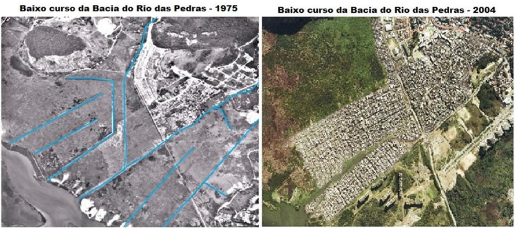
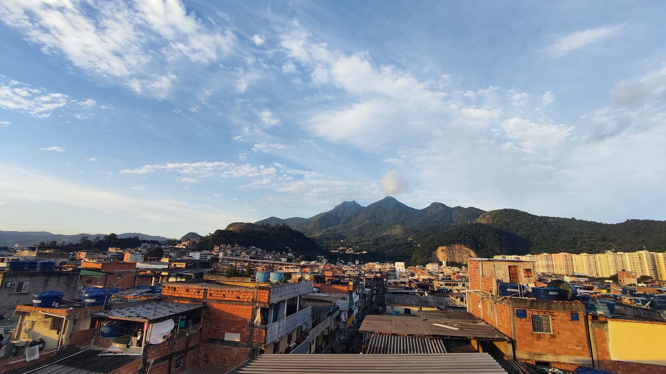
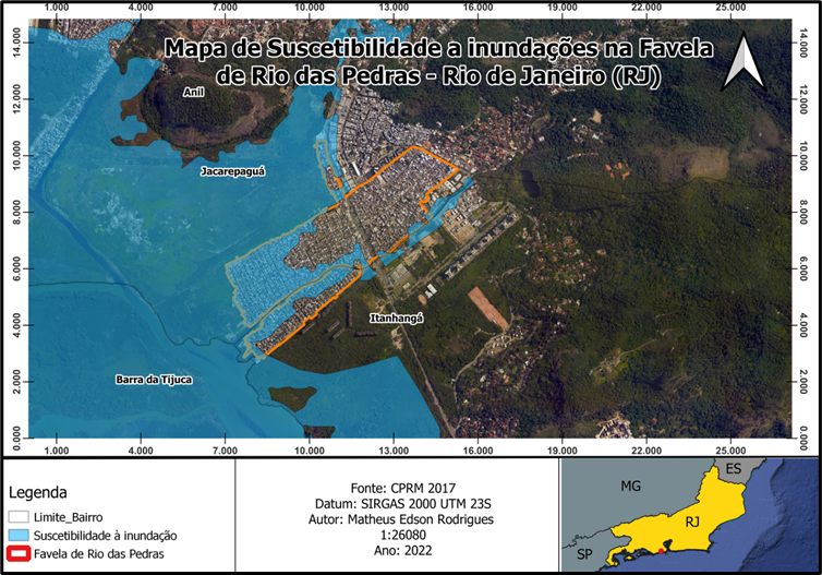
Rio das Pedras is located in the West Zone of the city of Rio de Janeiro, between the neighborhoods of Jacarepaguá and Itanhangá, in an area that is susceptible to flooding and is bounded to the north by the Tijuca Massif and to the south by the Tijuca Lagoon. In the Flood Susceptibility Map of the Rio das Pedras favela, it is possible to see that the favela expanded rapidly, spreading to large areas of the Baixada de Jacarepaguá region—more specifically the Rio das Pedras Basin. Upon arriving on the banks of the River of Stones (Rio das Pedras in Portuguese) new residents, especially migrants who came to work in the building of neighboring upscale Barra da Tijuca, built their houses in a variety of ways to meet their needs. The favela grew a lot and quickly, both vertically and horizontally, as well as up and down the main river. This pattern of urbanization caused different problems, including the increased risk of flooding.
Rio das Pedras has been one of the fastest growing favelas in the region. In a short time, it became one of the largest favelas in Brazil, ranking third with 27,573 homes. Even though it is extremely urban, the characteristically humid area of Baixada de Jacarepaguá, where the favela is located, is still noticeable. This is fundamental for a better understanding of the area, as neighborhoods in the region are built on infilled wetlands and mangrove areas.
The process of occupation and self-construction in swampy areas, without participation from the State or the provision of adequate infrastructure, has direct impacts on the daily lives of residents. They must deal with flooding, precarious water supply, lack of basic sanitation, and landslides due to the instability of the soil. Furthermore, residents report the issue of the tide, which causes them to face flooding sewage whenever the tide is high in Lagoa da Tijuca and Rio das Pedras. In these moments, a harmful mixture of sewage and lagoon water invades streets and homes.
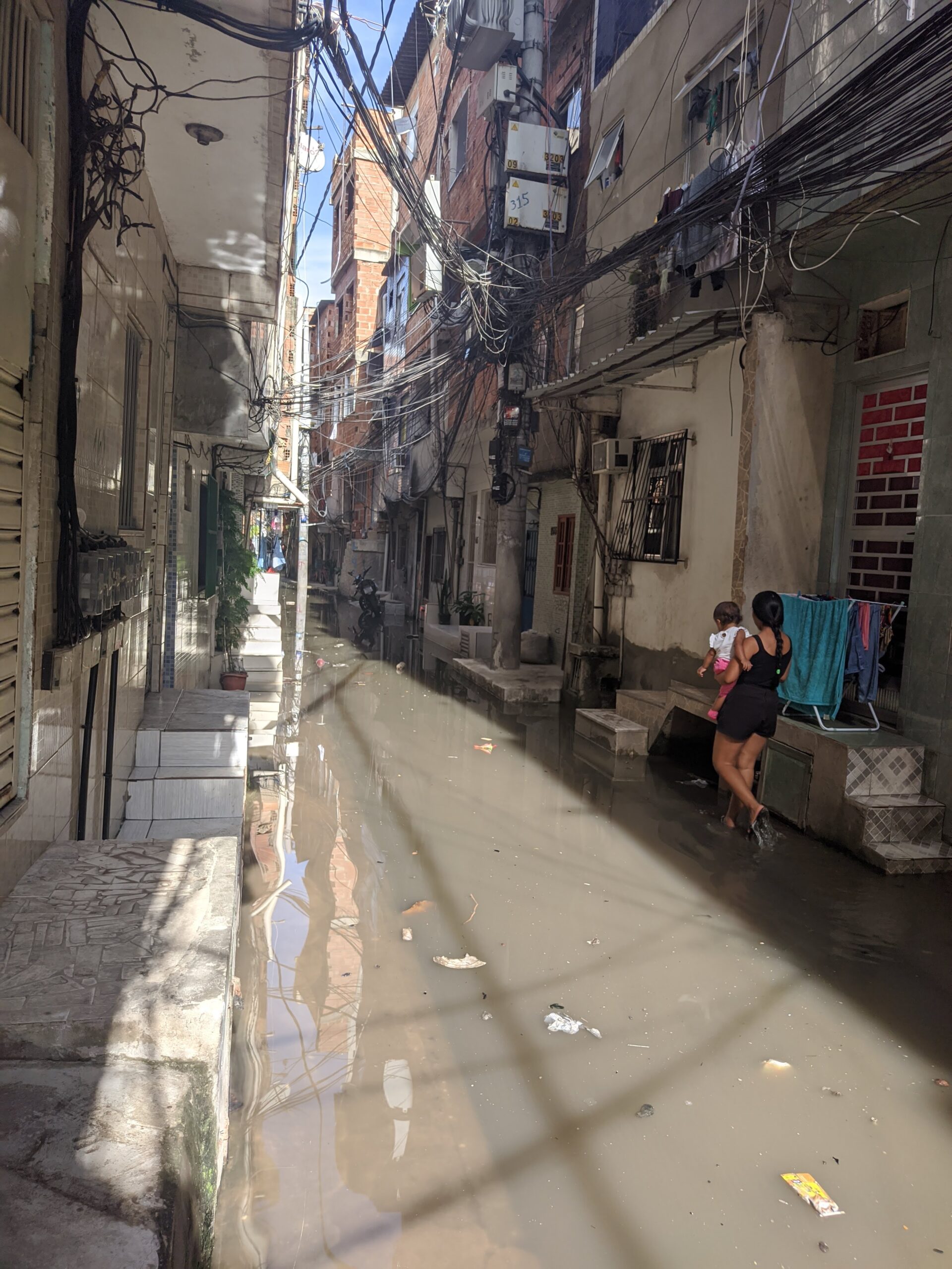
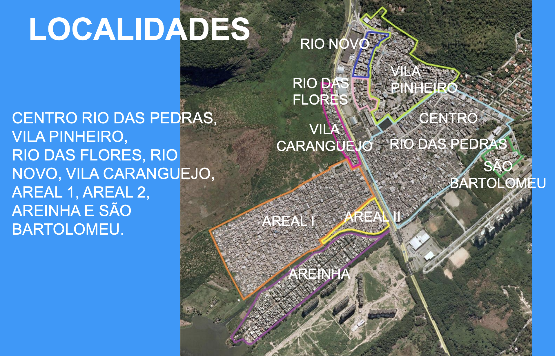
The photograph above shows precisely the area known as Areal 1, a street near the Tijuca Lagoon, flooded due to high tide. On the day of the photo, it had not rained in the area. However, the situation in the street was completely impaired due to precarious sanitation in concert with the high tide in the region. This impacts the right to come and go, as well as the health and housing of those who live there. For those who have no choice and have to work, study, or simply go out, there is no other option than to step in the sewage.
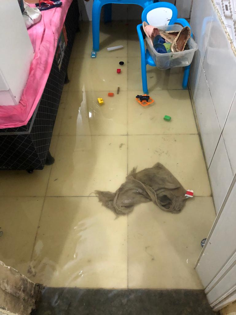
“In May 2022, a very sad and unpleasant situation happened in our house. There was a very heavy rain that year… water entered the house because the level rose a lot… Soon afterwards, without any heavy rain falling, I was working, my husband and I were working, and when we got home our house was full of water… the tide had risen. Water came in through the drain in the kitchen and bathroom… After a whole day working, we walked into that surprise: our house was full of water and, this time, without any rain but because the tide level was high… When we arrived, my son’s toys were under water. Things that were on the floor, like the refrigerator, washing machine, stove, carpets, you know, lots of things: we lost them all… It was very sad, a desperate moment. But as time went by, we managed, working to renovate, upgrade our house and raise it above the [ground] level it once was… Every time it rains or when the seas get rough, the tendency here is for the tide to rise and flood Rio das Pedras.” — Maria José Felizardo, resident of Areinha
Following Felizardo’s words, it is interesting to analyze what the Flood Susceptibility Map above shows. It is worthwhile to reflect on socio-environmental inequalities and how they affect residents of areas neighboring Rio das Pedras. It is evident on the map that both Rio das Pedras, Jacarepaguá and Barra da Tijuca have places with potential risk of flooding. However, when heavy rains or storm surges occur, is everyone affected in the same way and does everyone receive the same assistance from the State? What places are the priority for receiving investments aimed at containing these occurrences?
Rio das Pedras has undergone different spatial changes during its urbanization which, combined with advancing climate change, make some environmental events more frequent and destructive. Tide fluctuations have been reaching higher levels than before. Furthermore, this unsanitary water floods areas sealed by asphalt and cement, preventing drainage and soil infiltration. Therefore, these places also remain submerged for longer than before.
These regions used to be covered in mangroves, with permeable and forested soil. They were fully prepared to contain the tides and floods of the rivers and the lagoon. The once abundant local vegetation protected the coast and riverbanks from high tides, flooding, and erosion. The mangrove forest prevented floods from reaching the size and territorial extent they have today.
The location of Rio das Pedras in a lowland area, together with these factors and the chronic abandonment by the State, create conditions that make the local population vulnerable and victimized. However, the impact is not the same in neighborhoods nearby with the same geographic profile but with significant public investments and more wealth.
Socio-environmental Injustice in Rio das Pedras
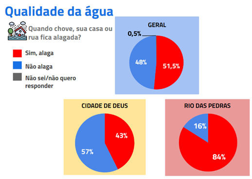
Residents of the Rio das Pedras favela were interviewed as part of the report on “Water and Energy Justice in the Favelas” launched by the Sustainable Favela Network and different community partners, organizers, leaders and youth from the area. More than half of those interviewed responded that they are directly impacted, having their homes or streets overrun by sewage from Lagoa da Tijuca during times of flooding. Rio das Pedras was above the average of the other 14 favelas included in the report. According to residents heard during the research, flooding has been a problem for decades, but the issue has worsened over the years.
Environmental injustices are inseparable from social inequalities. It is clear which places are prioritized in the city of Rio de Janeiro when it comes to facing extreme and natural climatic events and which are left to their own devices. Impacts are always larger for the population living in favelas.
Therefore, in addition to environmental injustice, socio-environmental injustice should be addressed and the form of socialization in each territory should be analyzed. For example, the resilience of favelas and of wealthier neighborhoods during summer rains is quite different. When considering favelas and peripheral spaces, we find a shortage of services, a lack of public policies and investments, and a lack of priority given by governments to local demands, which puts the lives and property of favela residents at risk.
How do Tides Occur?
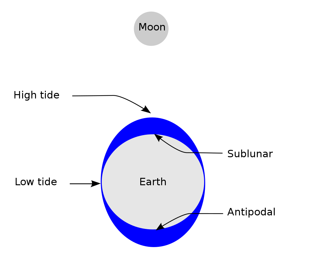
To explain the phenomenon of the tide, it is important to highlight that these are natural phenomena, governed mainly by astronomical forces. The dynamics between the Moon, the Sun and planet Earth directly influences the movement of seas, rivers, and lakes. The gravitational pull of these celestial bodies works like a magnet, attracting lighter substances on Earth. The movement of waters, which is called tide, is visible to the naked eye.
Therefore, over the course of a lunar day (24 hours and 50 minutes), any point on the Earth’s surface will experience two periods of low tide and two periods of high tide. The intensity of these tides can vary over bodies of water, depending on the phases of the moon. For instance, high tide might be more pronounced on full moon days, whereas during the new moon, low tide tends to be more intense.
In addition to astronomical factors, other phenomena help determine sea level, such as climate change, winds, the arrival of cold fronts, etc. In relation to rivers, rainfall, the rate of soil draining and the health of the forest on riverbanks, among other factors, influence their water levels.
The Life of Residents in Areal 1 and Areinha
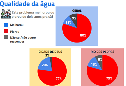
During the interviews for the “Water and Energy Justice in the Favelas” research course, one of the residents of Areal 1 reported several consequences of the street flooding without the need for rainfall. She stated, for example, that her water pump had already burned out because of high tide and the lack of adequate sanitation.
“When the tide rises, the street here where I live, on the side with the ditch, fills up. The water reaches the middle of the street… It floods a lot. I’ve been through water up to my knees. The only reason my house doesn’t fill up is because I live very high up, but I’ve seen a lot of people lose things, those who live lower down… we’ve already lost the water pump, for example… [the neighbors] already lost materials, wardrobes, sofas… I’ve seen a lot of people have to sleep outside because of the tide… The water even comes up over the toilet… I’ve seen a lot of that in people’s houses here… and it’s always the same when the tide comes in: the street floods and everyone has to take their things away… I met a woman who had to move because of the rising tide and every time it rose her house flooded… She had to leave her own house! Because of the tide! And here, in Areal, it’s always the same… Almost my entire street floods when the tide comes in.” — Jeane Carvalho
The context in which these socio-environmental injustices take place is very unequal, as public authorities prioritize areas of the city, where the interests of capital are greatest, for investment to make them climate and environmentally resilient. In this way, the favela population faces increasing vulnerability due to State negligence and socio-environmental and spatial inequalities. Within this setting, natural phenomena and extreme weather events impacting the entire city do not affect everyone in the same way.
About the author: Matheus Edson Rodrigues, born and raised in the Rio das Pedras favela, West Zone of Rio de Janeiro, is a community educator, geography teacher, and geographer with a degree from PUC-Rio. He is currently pursuing a master’s degree in Physical Geography at FFLCH/USP.
*The Sustainable Favela Network (SFN) and RioOnWatch are projects of Catalytic Communities (CatComm).

