

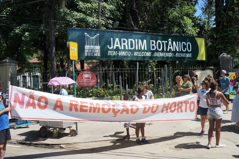
Horto is a lush favela community in the South Zone of Rio de Janeiro that has existed for over 200 years. The community, which was founded by former Botanical Gardens workers who were given permission to build homes on the land, including slaves in the Botanical Gardens’ early years, has been under threat of eviction since the 1960s. In 2013, and last week posted on the community’s new website, Horto was included on the Brazilian Conflict Map of Health and Environmental Injustice put together by the National Public Health School (ENSP) of Brazil’s national health institute, the Oswaldo Cruz Foundation (Fiocruz), in partnership with the NGO FASE and with technical support from the Health Science Information and Technology Institute (ICICT). The team at ENSP/Fiocruz worked with the Brazilian Environmental Justice Network (RBJA), building on previous environmental justice maps such as the Map of Environmental Conflicts in the State of Rio de Janeiro.
The map was originally launched in March 2010, with 297 cases reported, and new conflicts were added until reaching 571 in August 2016. It includes filters for location, population affected, and cause of conflict, as well as a search bar. “Our objective isn’t reduced to listing territories where risk and environmental impacts affect different populations, but to make public the voices that struggle for environmental justice of populations who are frequently discriminated against and made invisible by institutions and by the media,” writes the team. Each point on the map not only contains key facts about the conflict, but also includes a “synthesis” or summary of events with a long historical perspective, timeline and references. The team created a map that is not “closed,” that can “be the starting point for new reports, for the monitoring of public policies, and still, of the challenge for the state to, in its diverse levels, respond to the needs of the citizens.”

The creators of the map highlight the scales of potential solutions–that these problems must be addressed and solved on short, medium, and long-term time scales, and that institutions and economic systems may also need to be modified to respect the land rights and health of the affected populations.
The initial goal was to map around 15 major environmental conflicts in every Brazilian state. The team was interested in mapping the regional spread of certain types of environmental conflict throughout Brazil, which they chose to evaluate by “type of population affected or location of conflict” (indigenous peoples, workers, quilombolas, etc.), type of harm to health or environment (malnutrition, water contamination, etc.), context for conflict, and availability of previous research or information about the conflict. After data for each case were collected, the mapping team verified their information with activists or researchers working closely with the cause.

After analyzing results in the table (above), researchers found that the North and Northeast made up of 50% of cases, while São Paulo, Minas Gerais, Rio de Janeiro, Amazonas, and Bahia were also high ranking due to their high levels of industrialization and urban density, and subsequent pollution. These states are also known to have many activist movements. The team notes that the North, Northeast, and Central-West are experiencing new industries, bringing with them corporate agriculture and infrastructure projects.
Initial geographic data also highlighted different scales of the conflict: they noted that in certain states, such as Acre and Amapá, environmental conflicts involve nearly all of the state’s municipalities, while in states like São Paulo, much fewer were involved. Most of the environmental injustice and health cases are rural, which could result from the extraction of resources and exploitation of land. However, it is predicted that cases from urban conditions–garbage disposal, sanitation, etc. will rise in the next few years.

The map contains a detailed history of land use in the Horto region beginning in the colonial era. The bicentennial community is home to 589 families and is in danger of eviction by Rio’s Botanical Gardens. The summary explains that in 1811, the park leadership built housing for workers of the Gardens and Tijuca National Park on site. Since then, the community has grown, and in 1950, workers were given official permission to build homes closer to the Gardens. In the 1980s Horto began to face the first threats of eviction as Brazilian media corporation Globo and mansions arrived in the area.
In the 2000s, the redevelopment of the Solar da Imperatriz destroyed historical sites related to slavery. And in 2005, police violently intervened in Horto, resulting in the death of one resident and the injury of others. In 2010, Horto appeared on a list of communities slated for removal before 2012, predicated on some homes’ location in an area of environmental risk or environmental protection. That same year, the Horto Museum was recognized as a “point of memory” among Brazilian museums. In a second dossier in 2013, residents of Horto claimed their a to their traditional housing, and argued that their community is of historical value to the city of Rio de Janeiro. The summary follows with a variety of references for information about Horto.
Other cases in the City of Rio de Janeiro highlighted on the environmental injustice map include the Pedra do Sal Quilombo, which is fighting to “guarantee their space” in the rapidly changing Port Zone, and the Manoel Congo occupation which is developing restoration projects.
The map also contains a space for viewers to suggest new conflicts to be mapped, with the intention that the map will continue to grow as a space for awareness-raising and voice for these conflicts. However, recently the project’s funds were cut. Originally funded by the national Health Ministry through Fiocruz, the new federal administration cut resources so the project is paralyzed while its organizers seek out alternative funds that will allow them to maintain and expand on the map that has proved such an important tool for the communities facing conflict.
Article updated at 1:23pm on July 2, 2017.